


Lake Cumberland Area Development District (East) PUMA, Kentucky
About
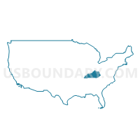
Outline
+PUMA%2c+Kentucky_A280.png)
Summary
| Unique Area Identifier | 192994 |
| Name | Lake Cumberland Area Development District (East) PUMA |
| State | Kentucky |
| Area (square miles) | 1,592.26 |
| Land Area (square miles) | 1,543.38 |
| Water Area (square miles) | 48.88 |
| % of Land Area | 96.93 |
| % of Water Area | 3.07 |
| Latitude of the Internal Point | 36.91608480 |
| Longtitude of the Internal Point | -84.63055430 |
Maps
+PUMA in Kentucky.png)
Graphs
Select a template below for downloading or customizing gragh for Lake Cumberland Area Development District (East) PUMA, Kentucky
+PUMA%2c+Kentucky_T0.png)
+PUMA%2c+Kentucky_T1.png)
+PUMA%2c+Kentucky_T2.png)
+PUMA%2c+Kentucky_T3.png)
+PUMA%2c+Kentucky_T4.png)
+PUMA%2c+Kentucky_T5.png)
+PUMA%2c+Kentucky_T6.png)
+PUMA%2c+Kentucky_T7.png)
+PUMA%2c+Kentucky.png)
Neighbors
Neighoring Public Use Microdata Area (by Name) Neighboring Public Use Microdata Area on the Map
- Bluegrass Area Development District (South) PUMA, KY
- Campbell, Claiborne, Scott, Morgan & Hancock Counties PUMA, TN
- Cumberland Valley Area Development District (North) PUMA, KY
- Cumberland Valley Area Development District (South) PUMA, KY
- Lake Cumberland Area Development District (West) PUMA, KY
- Putnam, Overton, Jackson, Clay & Pickett Counties PUMA, TN
Top 10 Neighboring County (by Population) Neighboring County on the Map
- Pulaski County, KY (63,063)
- Laurel County, KY (58,849)
- Campbell County, TN (40,716)
- Whitley County, KY (35,637)
- Lincoln County, KY (24,742)
- Scott County, TN (22,228)
- Wayne County, KY (20,813)
- McCreary County, KY (18,306)
- Russell County, KY (17,565)
- Rockcastle County, KY (17,056)
Top 10 Neighboring County Subdivision (by Population) Neighboring County Subdivision on the Map
- Somerset CCD, Pulaski County, KY (36,159)
- Williamsburg CCD, Whitley County, KY (11,340)
- Mount Vernon CCD, Rockcastle County, KY (10,943)
- Monticello CCD, Wayne County, KY (10,184)
- Keavy CCD, Laurel County, KY (9,524)
- Pine Knot CCD, McCreary County, KY (7,772)
- District 5, Campbell County, TN (7,566)
- Albany CCD, Clinton County, KY (7,345)
- Stearns-Whitley City CCD, McCreary County, KY (7,032)
- Eubank CCD, Pulaski County, KY (6,111)
Top 10 Neighboring Place (by Population) Neighboring Place on the Map
- Somerset city, KY (11,196)
- Monticello city, KY (6,188)
- Pine Knot CDP, KY (1,621)
- Stearns CDP, KY (1,416)
- Whitley City CDP, KY (1,170)
- Winfield town, TN (967)
- Ferguson city, KY (924)
- Science Hill city, KY (693)
- Burnside city, KY (611)
- Eubank city, KY (319)
Top 10 Neighboring Elementary School District (by Population) Neighboring Elementary School District on the Map
Top 10 Neighboring Secondary School District (by Population) Neighboring Secondary School District on the Map
Top 10 Neighboring Unified School District (by Population) Neighboring Unified School District on the Map
- Laurel County School District, KY (57,752)
- Pulaski County School District, KY (51,811)
- Campbell County School District, TN (40,716)
- Lincoln County School District, KY (24,742)
- Whitley County School District, KY (21,339)
- Scott County School District, TN (19,182)
- McCreary County School District, KY (18,306)
- Russell County School District, KY (17,565)
- Rockcastle County School District, KY (17,056)
- Wayne County School District, KY (16,922)
Top 10 Neighboring State Legislative District Lower Chamber (by Population) Neighboring State Legislative District Lower Chamber on the Map
- State House District 38, TN (60,599)
- State House District 36, TN (59,825)
- State House District 85, KY (46,596)
- State House District 83, KY (46,457)
- State House District 52, KY (44,854)
- State House District 80, KY (44,415)
- State House District 82, KY (42,490)
- State House District 24, KY (41,610)
Top 10 Neighboring State Legislative District Upper Chamber (by Population) Neighboring State Legislative District Upper Chamber on the Map
- State Senate District 15, TN (193,013)
- State Senate District 12, TN (188,880)
- State Senate District 34, KY (124,714)
- State Senate District 15, KY (115,239)
- State Senate District 21, KY (105,934)
- State Senate District 16, KY (102,847)
Top 10 Neighboring 111th Congressional District (by Population) Neighboring 111th Congressional District on the Map
- Congressional District 6, KY (759,205)
- Congressional District 4, TN (688,008)
- Congressional District 1, KY (686,989)
- Congressional District 5, KY (670,051)
Top 10 Neighboring Census Tract (by Population) Neighboring Census Tract on the Map
- Census Tract 9604, McCreary County, KY (7,772)
- Census Tract 9603, McCreary County, KY (7,032)
- Census Tract 9751, Scott County, TN (6,846)
- Census Tract 9305.02, Pulaski County, KY (6,548)
- Census Tract 9305.01, Pulaski County, KY (6,124)
- Census Tract 9202, Wayne County, KY (6,121)
- Census Tract 9301, Pulaski County, KY (6,111)
- Census Tract 9308, Pulaski County, KY (5,925)
- Census Tract 9204, Whitley County, KY (5,899)
- Census Tract 9302, Pulaski County, KY (5,534)
Top 10 Neighboring 5-Digit ZIP Code Tabulation Area (by Population) Neighboring 5-Digit ZIP Code Tabulation Area on the Map
- 40701, KY (29,497)
- 42503, KY (22,894)
- 40741, KY (21,875)
- 42633, KY (20,065)
- 40769, KY (18,507)
- 40744, KY (18,334)
- 42501, KY (17,592)
- 42642, KY (12,573)
- 42602, KY (10,216)
- 42539, KY (10,026)